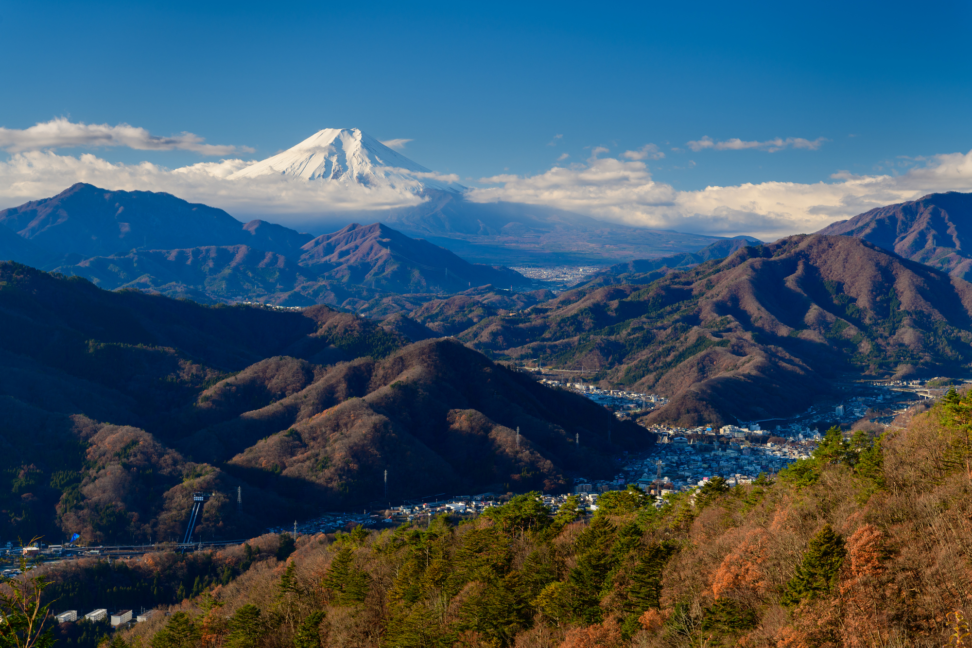
Mt. Momokura (Momokura-yama, 1,003m) is located in Otsuki City, Yamanashi Prefecture. Counted as one of Otsuki City’s symbolic “Twelve Views of Mt. Fuji”, the view of Mt. Fuji from the summit is breathtaking. Additionally, at the foot of the mountain is Saruhashi Bridge, one of Japan’s three most unusual bridges, making it a great point to enjoy both hiking and sightseeing together.
If you’re wondering about the best way to get to Mt.Momokura, keep in mind that the distance to the trailhead varies greatly depending on whether you take the train or the highway bus.
In this article, we will thoroughly compare the three access methods (car, train, and highway bus) from Shinjuku to Hyakkurayama Trailhead (on the Saruhashi Station side).
Access Comparison Table (Shinjuku → Mt. Hyakkura Trailhead)
To reach Mt.Momokura, the shortest distance to walk is by car, followed by highway bus. Note that the train is the longest walk.
| Means of transportation | Price One-way (Approximate) | Time taken | Trailhead (Wada Art Museum) Distance / Walking time required | Number of Transfers |
| Highway bus Reservation | Approx. 1,550 yen | About 75 minutes | Approx. 2.1 km / 43 min. Map | 0 times |
| Train | Approx. 1,340 yen | About 100 minutes | Approx. 2.8 km / 54 min. Map | 0 to 1 times |
| Car | Express charge Approximately 2,000 yen one way + Fuel cost Free parking | Approx. 70 min. | Approx. 1 km / 22 min. Map | 0 times |
*”Trailhead” here refers to the “Mt. Hyakkura trailhead (near the Wada Museum of Art),” where you can enter the full-scale mountain trail.
* The “Distance” for cars is the distance from the main parking lot (Otsuki Municipal General Grounds).
Otsuki Municipal Grande Wada Art Museum Google Map
Access by Highway Bus (Chuo Highway Bus)
Not surprisingly, this route is highly recommended for public transportation users, as it stops closer to the trailhead than the train.
Basic route
- Shinjuku Bus Station → ( Chuo Highway Bus Kofu Line ) → get off at “Chuo-do Saruhashi” bus stop
In addition to “Shinjuku Bus Station” bus stops along the way such as ” Fuchu Bus Stop ” and ” Hino Bus Stop” are also available.
Distance and time to the Hyakkurazan Trailhead
The bus stop is on the highway north (mountain side) of the station. Walking from here is shorter than the route from the station.
- Section: Saruhashi bus stop on the Chuo Expressway – Hyakkurayama trailhead (near Wada Art Museum)
- Distance: Approx. 2.1 km
- Walking time required: Approx. 43 min.
- Once you exit the steps at the bus stop onto the public road, it is a relatively short walk to the trailhead. Compared to the route from the station, this route saves about 10 minutes.
Advantages of the bus
- Short walking distance: closest to the trailhead among public transportation options
- Comfortable: you have a guaranteed seat from Shinjuku, no transfers, and many buses have Wi-Fi and power outlets
Disadvantages
- Traffic risk: Traffic jams, such as on weekend return trips, can delay arrival times
For details and reservations for highway buses, please visit ” highway-bus.com “.
Access by Train (JR Chuo Main Line)
This is the most popular and reliable method for climbers, but takes about an hour walk to the trailhead.
Basic route
Shinjuku Station → (JR Chuo Line or Keio Line) → Takao Station → (JR Chuo Line, ordinary) → Saruhashi Station
Distance and time to trailhead
Take the north exit from the station and walk through the residential area and a long slope to the trailhead.
- Section: JR Saruhashi Station – Mt. Hyakkura trailhead (near Wada Art Museum)
- Distance: Approx. 2.8 km
- Walking time required: Approx. 54 min.
- The entire route is paved, but there is a continuous uphill climb. Think of the walk as preparation for the hike ahead!
Advantages
- Accurate time: no traffic jams, stays on schedule
Disadvantages
- Walking distance: The 54-minute driveway walk one way to the trailhead can be strenuous, especially in summer.
- Train congestion: Trains are crowded on weekends and during the season, and it is sometimes difficult to find a seat on the train
Access by car
It is the least strenuous way to get close to the trailhead. A large, free parking lot is also available.
Basic route
- Chuo Expressway → Otsuki IC → via Route 20 (Koshu Kaido)
- Navigation system setting: “Otsuki Municipal General Ground
Distance to parking lot and trailhead
The parking lot of the “Otsuki Municipal General Grounds” is generally used for climbing Mt.Momokura
- Parking: Otsuki City General Grounds (approx. 100 cars, free of charge) Trailhead Navigation Parking Information
- Section: Parking lot – Mt.Momokura
- Distance: Approx. 1.0 km
- Walking time required: Approx. 22 min.
- From the parking lot to the trailhead, a there is a paved uphill slope. Once up here, the rest is a mountain trail.
Advantages
- Shortest approach: minimize walking on the roadway
- Free parking: many parking spaces are available free of charge.
Disadvantages
- Traffic jam: Risks of possible traffic jams on the Chuo Highway (near Kobutsu Tunnel) on the way home on weekends, etc. Driving home can be difficult.
- Restrooms: The restrooms in the parking lot of the grounds may be closed, so either use the bathroom in advance or use the public restrooms along the trail.
Summary: Which way do you recommend?
- If you want a straightforward way which minimizes the walking distance: Car
Using the municipal ground parking lot is the smoothest way. - If you prefer not to walk, and don’t mind taking public transportation: Express Bus
The “Chuo-do Saruhashi” bus stop is actually a good spot close to the trailhead. There are many buses available. It is also the best way if you want to conserve your energy! - If you worry about your schedule: “Train”
Although the walking distance is longer, the return time can be exact due to reliable train times.
Mt.Momokura is a wonderful mountain that can be climbed in a short time and offers a spectacular view of Mt.Fuji! Please use the access method that best suits your style and have an enjoyable day!
For details and reservations for highway buses, please visit highway-bus.com.